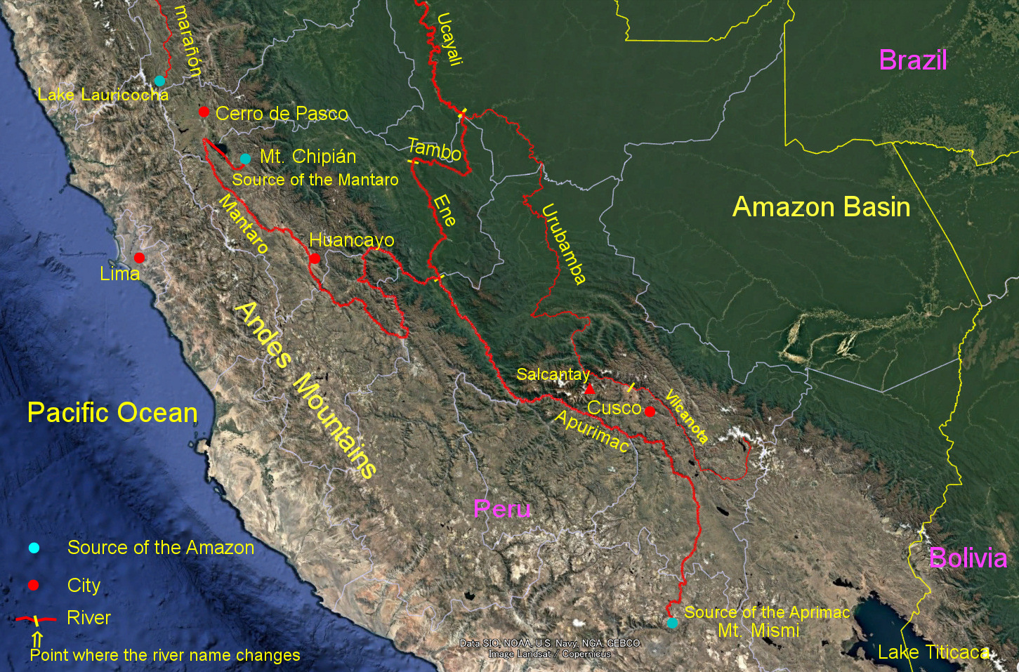
Information about the source of the Amazon River (the point farthest along the channel from the mouth of the river) has changed in many ways. Until the 1950s, when there were no accurate maps, it was thought that the main course of the Amazon River was the Marañón River, and its source was near Lake Lauricocha (upper left in the image). In the 1950s, when detailed maps based on aerial photographs were available, the Ucayali River is longer than the Marañón River, and it is thought that the source of the Amazon River is the Apurimac River, which forms the upper reaches of the river. Several tributaries in the upper reaches of the Apurimac River in southern Peru were candidates, but a paper based on a detailed field survey in 1999*1) led to the idea that Mount Misumi (Nevado Mismi) is the source of the Amazon River. This is the theory that is now commonly believed.
Lengths of the Apurimac and Mantaro rivers according to various measurement methods
| Auther | Measurement method | Apurimac River (km) | Mantaro River A (km)* | Mantaro River B (km)** |
|---|---|---|---|---|
| Contos & Tripcevich | Google Earth satellite image | 731.2 | 806.6 | 806.2 |
| 〃 | GPS-equipped canoe*** | 734.3 | 809.0 | 808.7 |
| 〃 | Topographic map | 707.0 | 784.7 | 783.7 |
| Homepage PanoraGeo | Google Earth satellite image | 707.2 | 791.1 | 792.1 |
* Length from the Rumi Cruz Range, where Contos and Tripcevich considered as the source of the Amazon
** Length from Mt. Chipián, where Homepage PanoraGeo considered as the source of the Amazon
*** Method of going down the river in a canoe with a GPS device and determining the length of the river from the trajectory
However, in recent years, objections to this have begun to emerge. The source of the Amazon River is not in the Apurimac River, but in the upper reaches of the Mantaro River, according to a paper by Contos and Tripcevich (2014)*2). The Mantaro River merges with the Apurimac River in the Andes to become the Ene River, then changes its name to the Tambo and the Ucayali, and finally become the Amazon. Contos & Tripcevich measured and compared the lengths of the Mantaro and Apurimac rivers in various ways, and the results of the relatively accurate method are cited in the table on the right.
The author of the Homepage PanoraGeo made a follow-up measurement using a recent Google Earth image with improved quality. It was measured in a way that was as close to Contos & Tripcevich as possible, i.e., the water source should be on the watershed surrounding the drainage basin; the part where the flow path is unclear, such as the headwaters, should be connected by a straight line; and the entrance and outlet of a natural lake should be connected by a straight line (refracted if there is a cape), and so on. The table shows that the Mantaro River is about 10% longer than the Apurimac River in any methods. Therefore, it is certain that the source of the Amazon River is in the upper Mantaro River in central Peru.
Looking at this table, we can see that the values of Contos & Tripcevich's "Google Earth satellite image" and "GPS-equipped canoe" (blue numbers) are approximate, that is, the measurement of satellite images yields almost the same results as the time-consuming rafting survey. For this reason, they suggest that satellite photographs are generally better used to measure the length of rivers.
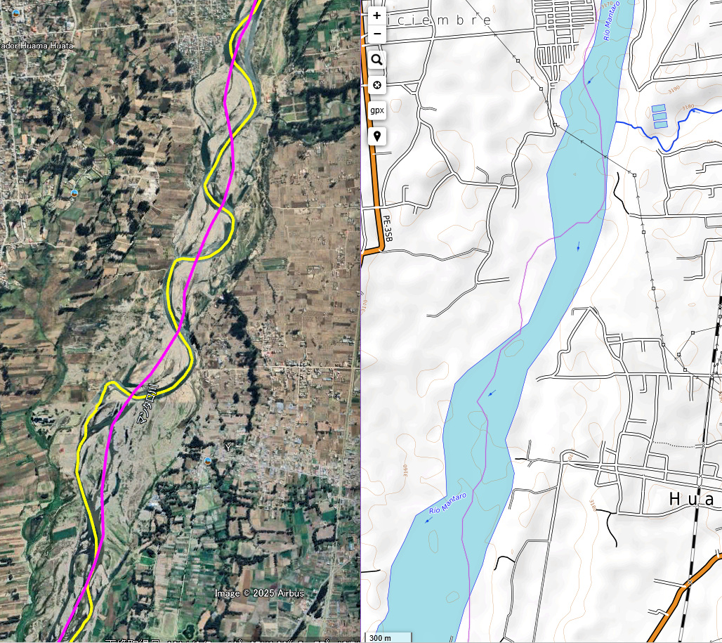
Satellite image of the middle course of the Mantaro River near Huancayo City (left) and topographic map (OpenTopoMap) of the same area (right)。
●The yellow line in the satellite image is the center line of the low-water channel, and the pink line is that of the bankfull channel.
It is obvious that the centerline of the low-water channel is longer.
●A detailed topographic map like the one on the right depicts the river channel (bankful channel) as a river. Therefore, if you measure using a detailed topographic map, you can get a result similar to that of measuring the center line of the river channel with a satellite photo (red numbers in the table)
That's true, but there's a problem with the following: compared to the values on the Homepage PanoraGeo (bottom row in the table), the values from the Google Earth satellite imagery of Contos & Tripcevich (top row) are 3.4% larger for the Apurimac River and 2.0-1.8% larger for the Mantaro River. Why did these differences arise while using satellite imagery in the same way?
Satellite imagery, with rare occasions, shows the river in good weather and low water levels. Presumably, Contos & Tripcevich measured the centerline of such a low-water channel. In addition, the descent of the river to obtain the GPS trajectory is probably done when the water level is low, so the result is still the length of the centerline of the low-water channel. On the other hand, Homepage PanoraGeo first interprets the river channel with the satellite image and then measures its centerline. Here, the river channel refers to the entire width of the river, including the riverbed that is not covered by water at low water, and is technically called bankfull channel *3).
The flow of the low-water channel is quite flexed, as it flows away from micro-reliefs such as point bars inside the meanders and sand and gravel bars of the braided stream. Therefore, the low-water channel is longer than the river (bankfull) channel (see the figure on the right). This is why different results have been obtained using similar satellite image. Therefore, the question arises as to whether the low-water channel or the river (bankfull) channel should be measured, but common sense tells us that the true length of the river is the centerline of the river (bankfull) channel.
*1) Jansky, B.(1999): A New Survey of Sources of the Amazon.
*2) Contos, J. & Tripcevich, N. (2014): Corrent placement of the most distant source of the Amazon River in the Mantaro River draigage. Area, 46.1.
*3) Bankfull channel means channel width between the tops of the most pronounced bank on either side of a stream reach where water would just begin to flow out onto the floodplain.
Explanatory material for No.28. Follow the Immense River, the Amazon P.2