
Fig.1. 2012 Google Earth satellite image (red line shows 1981 channel)
Fig.1. 2012 Google Earth satellite image (red line shows 1981 channel)
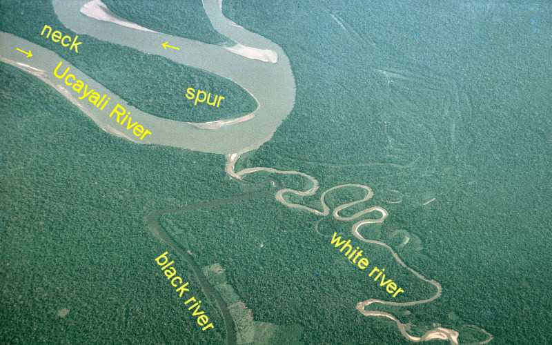
Fig.2. 1981 photo of PanoraGeo
Fig. 1 shows a Google Earth satellite image taken in 2012 with a red line showing the position of the Ucayali River and its tributaries in 1981 shown in Fig. 2.
●In the main stream of the Ucayali River, a meander cut-off occurred in the meander neck which was quite narrow even in 1981, and the length of the Ucayali River was shortened by about 7 km even only here.
●The course of the white river has changed so much that it looks completely different from what it was in 1981, but the course of the black river has hardly changed.
●The fundamental difference between a white river and a black river is the amount of sediment transport. In a white river with a large amount of sediment, the process of sediment deposition on one side of the channel and scraping the other side is sustained, and a meander develops, but this does not happen in the black river, where there is almost no sediment transport, and it is difficult for the river channel to change.
●In the Amazon Plain, there are many rivers that have extremely low levels of sediment transport. These are the "clear river" (rio claro), which is almost colorless and transparent, and the "black river" (rio preto), which is not turbid but has a color like a cola drink because it contains tannins.
Explanatory material for No.28. Follow the Immense River, the Amazon P.6