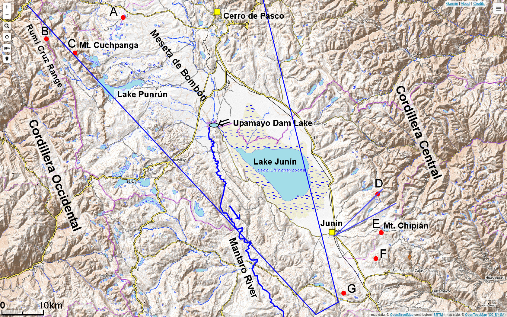
| River Source | Location | Latitude and Longitude (deg.) | Length to Upamayo Dam (km) HP PanoraGeo : Contos & Tripcevich |
|---|---|---|---|
| A | Bombón Plateau | -10.676933, -76.471698 | 66.6 ---- |
| B | Rumi Cruz Range | -10.731531, -76.646083 | 67.8 68.7 |
| C | Mt. Cuchpanga | -10.757834, -76.585570 | 68.0 67.9 | D | Junín City NE | -11.071656, -75.895290 | 68.1 64 |
| E | Mt. Chipián | -11.156628, -75.885343 | 68.8 68.4 |
| F | Junín City SE | -11.208512, -75.900704 | 68.1 ---- |
| G | Junín City South | -11.294404, -75.968279 | 66.8 63 |
The source of the main tributary of the upper Mantaro River and the length to the Upamayo Dam
(Red number: the longest tributary)
The map above is a topographic map of the upper reaches of the Mantaro River *1) located high in the Peruvian Andes. Between the Western Cordillera of the Andes on the left and the Central Cordillera on the right, the Bombón Plateau with Lake Junín and hilly mountains stretch out, and the Mantaro River flows south through the center. It is a somewhat civilized area, with the national highway No. 3 traversing the high altitudes of the Andes, along the route cities such as Cerro de Pasco, which has a large non-ferrous metal mine, and Junín.
To the northeast of Lake Junín is the Upamayo Dam, which dammed the Mantaro River, and the section downstream from here to the point where it joins the Apurimac River to become the Ene River, is called the Mantaro. Its length is 723 km, which alone is longer than the 707 km of the Apurimac River. Therefore, one of the tributaries upstream of the Upamayo Dam should be the "headwater" of the Amazon.
In the paper by Contos & Tripcevich (2014)*2) , which asserted the source of the Amazon River is in the upper reaches of the Mantaro River, the longest tributary is the river that originates in the Rumi Cruz Range (point B on the map) west of the Bombón Plateau and flows via Punrún Lake. However, this tributary is not much longer than the other tributaries, and there are many tributaries of almost same size. Therefore, using Google Earth images, a follow-up measurement on the length to the Upamayo Dam for several tributaries was made by the author of the Homepage PanoraGeo.
The results are shown in the table, which differed considerably from Contos & Tripcevich: The longest river originated on the southern slope of Mt. Chipián (point E on the map, elevation 4,751 m)in the Central Cordillera east of Lake Junín. This river, which flows close to residential areas of Junín City and flows into Lake Junín, has been artificially shortened in various places, such as short cut of meanders, but it was still the longest. The Mantaro River, which originates in Mt. Chipián, is 792 km long, 85 km longer than the Apurimac River. In this measurement, the result is subtle, with seven tributaries within a difference of about 2 km, so further follow-up tests are desired. As a document, I attach a KML file of the water system map created in this measurement. After downloading, it was opened and used on Google Earth (Download Amazon River Headwaters Study Materials)*3)。
So, is the Amazon River, 85 km long, the longest in the world? The results measured in the 2024 images were Mantaro River: 792 km, Ene River + Tambo River: 331 km, Ucayali River: 1,534 km, Amazon River (from the confluence of the Ucayali and Marañón to the sea): 3,629 km, for a total of 6286 km (Download the Amazon River Length Measurement Document)*4)。 In the 2021 edition of the Science Chronology, the length of the world's rivers is 6,695 km for the Nile River and 6,380 km for the Yangtze River, and the Amazon River at 6,286 km is the third longest. However, it is unclear how the Nile and the Yangtze River were measured, so it is impossible to accurately rank them at this time. In this age of satellite photography, it can only be said that this field is lagging behind.
*1) Base map:OpenTopoMap. The large blue fan shape in the map is the angle of view (shooting range) of the photograph on page 3 of the main text, and the small fan shape is that of the photo on page 4.
*2) Contos, J. & Tripcevich, N. (2014):
Corrent placement of the most distant source of the Amazon River in the Mantaro River draigage. Area, 46.1.
*3) The P738c-UpperMantaro.kml file downloaded here is a kind of folder that contains KLM files for each tributary, which shows the water source and flow path of each tributary on Google Earth satellite image.
If you double-click on this folder name in "Pending" at the bottom of the "Location" on the left side of the Google Earth screen, a tree of KLM files such as #A-river will appear.
Right-click on each KLM file and click Properties to get the edit path, and the "Measure" shows the length of the river.
*4) The folder P738d-AmazonTotal.kml contains four KLM files of the Amazon River divided into sections from the headwaters (Mantaro River) to its mouth, and a KLM file of the Apurimac River.
Explanatory material for No.28. Follow the Immense River, the Amazon P.3