| Return to the previous page |
Content↑ | Next Page |
28. Follow the Immense River, the Amazon Part 2: Brazilian Amazon
Expanded and revised on March 06, 2025
When you tap on a photo or diagram, a larger image will pop up and return with ✕ in the bottom right.

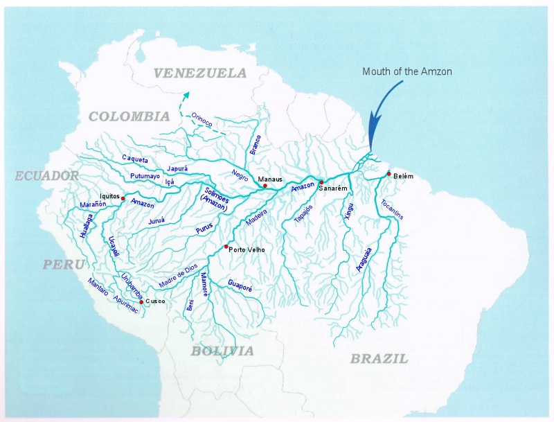
Drainage Network of the Amazon River
The Amazon River, which is not as long as the Nile River in Africa and may even lose to the Yangtze River, is by far the largest river in the world in terms of basin area and discharge. The uppermost part of the river flows through the river valley of the rugged Andes mountains, then into the flat lowlands, and flows through meandering channels that changes shape from moment to moment. In the middle stream it flows through a remarkably deep channel, and finally flows in the estuary (triangular river mouth) scattered with large and small islands to flow into the Atlantic Ocean. We will trace this great river that flows down while changing its character, from upstream to downstream.
About this map of drainage network: Based on the drainage net chart by M. Goulding et al. (2003) "The Smithsonian Atlas of the Amazon (Smithsonian Books) p.101", it was created by emphasizing major rivers and supplementing major city and place names. In addition, the upper reaches of the Orinoco River, where part of the flowing water diverts to the Casiquiare River in the upper reaches of the Negro River, were added with a dashed line.
| PanoraGeo Contnt↑ | Next Page↓ |
| Follow the Amazon River | 10 /21 | Previous Page | Next Page |

Solimões River and alluvial islands
In Brazil, the main stream of the Amazon River before it joins the Negro River in Manaus, the capital of the state of Amazonas, is called the Solimões River, and the Amazon River is downstream. The photo shows the Solimões River just before it merges with the Negro River, and if you look closely, you can see the darkened water surface on the far left side of the photo, which is the confluence with the Negro River. About half of the water in the entire Amazon system comes from the Solimões River, and other half flows from the Negro River and tributaries such as the Madeira, Tapajós, and Xingu that join the Amazon downstream from Manaus.
As you can see in the photo, the Solimões River is a typical muddy river (locally called the "white river"), and the accumulation of this abundant mud forms a floodplain. There is a small island in the river on the right side of the photo, but to the left of it is the island of Machantaria, and to the left of it is the island of Xiborena. These islands are lowlands of the same nature as ordinary floodplains, surrounded by natural levees and with swamps and lakes (back marsh) inside. This is a relatively stable terrain formed by the gradual accumulation of mud from the Amazon River. It is clear that it is not an unstable sandbar that moves and disappears every time by major floods, as evidenced by the abundant vegetation and the rows of houses along the river. In English, such an island is called "alluvial island", that means islands formed by the deposition of clay, sand, silt, or other material by flowing water.
Photographed on March 15, 2006 Camera position; (Latitude and Longitude):-3 18 37.92, -59 58 57.38 (Google Map) Shooting direction:33°clockwise from north
PanoraGeo-No.172
| Previous Page | Next Page ↓ |
| Follow the Amazon River | 11 /21 | Previous Page | Next Page |

Port of Manaus, the central city of the middle Amazon
The common means of transportation for people in the Amazon region is water transportation, and the Amazon River is its main street. At the port of Manaus, the capital of the middle Amazon basin, many liners are waiting to set sail to ports along the main tributary of the Amazon River. Liners from Manaus can be roughly divided into three routes: It runs along the main Amazon River (Solimões River) to Tabatinga on the border of three countries, Brazil, Peru and Colombia; down the Amazon River to Belém near its mouth; and along its tributary Madeira River to Porto Velho. There are also 1-2 long-distance liners a week to these terminals while calling at cities along the way, but most of them are medium-distance liners that shuttle to and from ports along the way.
Since the annual change in the water level of the Amazon River in Manaus is as large as 10 meters on average, the orange pier to which small ships are tied in this photo is a floating pier that rises and falls with the water level.
Photographed on March 10, 2005 Camera position; (Latitude and Longitude):-3 8 27.39, -60 1 25.04 (Google Map) Shooting direction:142°clockwise from north
PanoraGeo-No.403
| Previous Page | Next Page ↓ |
| Follow the Amazon River | 12 /21 | Previous Page | Next Page |

Passengers on a liner on the Manaus-Belém Route
The liner from Manaus to Belém was, and still is, the fastest time is 3 nights and 4 days, and the reverse Belém to Manaus is 4 nights and 5 days. If you pay about 80% more than the normal fare on a relatively large liner, you can upgrade from regional class to tourist class, and you can use a 3-4 person room with a bed and also can use the upper deck as shown in the photo. Regional class passengers must bring a hammock and sleep in it hanging on the lower deck.
After leaving Manaus the evening before, the ship after breakfast was sailing off the coast of the Mocambo district, an agricultural settlement on the outskirts of the city of Parintins. The next port of call, the city of Parintins, is about 3 hours away. The ship descends the middle Amazon with a photographed plateau (terra firme) on the left bank and the vast floodplain of Tupinambarana Island on the right bank.
Photographed on July 12, 1981 Camera position; (Latitude and Longitude):-2 26 11.19, -57 21 30.62 (Google Map) Shooting direction:328°clockwise from north
PanoraGeo-No.404
| Previous Page | Next Page ↓ |
| Follow the Amazon River | 13 /21 | Previous Page | Next Page |

Cape Remanso and constricted portion in the middle Amazon
The Amazon River flows off the coast of the Mocambo area, about 70 km west of the city of Parintins, from the upper left to the bottom of the photo. Inside the gently curved channel (left in the photo) is the floodplain of Tupinambarana Island, bordered by natural levees. On the outer bank of the curve (right in the photo), the Amazon River directly washes the foot of the upland (terra firme), part of which the Cape Remanso (Ponta do Remanso) protrudes in an angular shape. For this reason, the Amazon River in this part is a narrow section about 2 km wide. In such a narrow section, of course, the water depth is large at the expense of narrowness, and the depth off Cape Remanso is as large as 91 m. Not only here, but the riverbed in the middle Amazon is deep, usually about 60 meters, and in some places it is over 100 meters deep (See:Depth and flow velocity of the Amazon River).
Photographed on August 14, 2002 Camera position; (Latitude and Longitude):-2 42 33.80, -57 11 27.37 (Google Map) Shooting direction:329°clockwise from north
PanoraGeo-No.405
| Previous Page | Next Page ↓ |
| Follow the Amazon River | 14 /21 | Previous Page | Next Page |

Cape Remanso and the river bank collapse
The upland around Cape Remanso, which juts out into the Amazon River, is composed of continental sandstone and mudstone formations from the late Cretaceous period of the Mesozoic era, called the Alter de Chão Formation. In general, it is a stratum that does not have a very high degree of consolidation, but if there is a slightly hard layer locally in it, a protrusion like this Cape Remanso is formed. Due to the severe erosion of the Amazon, the river bank upstream from the tip of the cape is a series of vertical cliffs, and in some places, collapses are occurring, as shown in the photo.
The sediment generated by such a collapse is carried by the flow of the Amazon River and deposited in nearby riverbeds and riverbanks, causing river channel fluctuation. In the middle and lower reaches of the Amazon, the materials carried by river and those that make up the banks are mainly mud (fine-grained substances such as clay and silt). Such rivers are generally deep relative to the width, and they rarely change their flow paths, so to speak, they are "docile rivers". However, there are some places along the Amazon, such as this one, where slopes of upland collapse and supply coarse-grained substances such as sand that cause riverbed fluctuations. For this reason, the Amazon has not been able to become a completely "docile river".
Photographed on August 11, 2002 Camera position; (Latitude and Longitude):-2 27 23.80, -57 20 1.22 (Google Map) Shooting direction:73°clockwise from north
PanoraGeo-No.408
| Previous Page | Next Page ↓ |
| Follow the Amazon River | 15 /21 | Previous Page | Next Page |

Alluvial islands downstream of Remanso Cape, middle of the Amazon
The Amazon River flows from the upper left to the lower right of the photo, and near the upper left corner of the photo, you can see Cape Remanso, which protrudes into the river in a horn shape. On the other side of the river, from left to bottom of the photo, on the right bank of the Amazon, there are floodplains with many water surfaces, such as floodplain lakes and waterways. Since it is the high-water season of June, some of the water surface is brown due to turbid water flowing from the Amazon. This floodplain is part of the vast Tupinambarana Island.
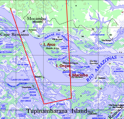
The Amazon River widens sharply downstream of Cape Remanso and flows between several alluvial islands*1). According to the topographic map on the right, the alluvial islands are roughly divided into Arco Island, Onças Island, and Marinho Island from the north, but the southernmost island (in the foreground) is mostly submerged during this period, which is the high-water season, and only the high part dispersedly appear on the surface of the water. Of the waterways that divide these islands, the one in front of the topographic map as “RIO AMAZONAS” is the main stream of the Amazon, where the valley line (Thalweg, the deepest part) is located, and the rest are secondary streams. In this region, such a secondary channel is called Paraná . In the middle and lower reaches of the Amazon, there are no drastic changes in the flow path as seen in the upper reaches of the Amazon(for example HERE), but riverbed changes such as the growth and disappearance of alluvial islands occur frequently. (See: Change in alluvial islands)
Photographed on June 27, 1981 Camera position; (Latitude and Longitude):-2 47 46.54, -57 13 54.38 (Google Map) Shooting direction: 357°clockwise from north
PanoraGeo-No.406
| Previous Page | Next Page ↓ |
| Follow the Amazon River | 16 /21 | Previous Page | Next Page |

The Amazon, branching and merging, but it is not a braided river

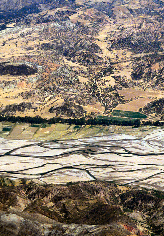
A braided river in the Andes Mountains, the Capinota River south of the city of Cochabamba, Bolivia.
This photo was taken looking upstream of the Amazon River in the Mocambo district, west of the city of Parintins in the eastern part of Amazonas state. The backlit water surface is beautiful with white reflections.
The Amazon repeatedly merges with diversions, and flows while embracing alluvial islands between the diversion channels. The technical words that immediately come to mind when you look at such a photograph are braided stream or braided river (photo on the right). The general explanation on the braided river is: 'rivers consisting of many shallow waterways and sandbars. They develop in the upper reaches of rivers near the mountains, and when flood arises, the channels merge to form a single thick flow. Gravel and sand are deposited by braided rivers'.*1) However, the underlined part of this quote does not apply at all to the Amazon River in this photo. The Amazon River in this part has a deep channel and is far downstream from the mountains, and it does not become a single flow when the water rises, and it is a river that accumulates mud.
Until several decades ago, rivers like the Amazon in this picture were also called braided rivers based only on the similarity of patterns, but now they are distinguished. The river like this picture of the Amazon is called the Anastomosing River, but the Branching Channel indicates a similar topography too.
The fundamental difference between a braided river and an anastomosing river is whether the area between the waterways is an unstable bar that is completely submerged by flooding and moves or disappears, or an alluvial island that is stable enough for vegetation to grow. The branched channels found in the delta at the mouth of the river and the delta islands between them also belong to the latter(See:Classification of rivers based on channel patterns (planar shapes)).
*1) Geological Survey of Japan, AIST: Earth Science in Pictures: Braided river(in Japanese)
Photographed on August 14, 2002
Camera position; (Latitude and Longitude):-2 42 24.96, -56 59 19.72 (Google Map)
Shooting direction:313°clockwise from north
Position of the center of the photo:-2 28 37.40, -57 15 4.64 (Google Map)
PanoraGeo-No.397
| Previous Page | Next Page ↓ |
| Follow the Amazon River | 17 /21 | Previous Page | Next Page |

A cruiser from Europe that called at the Port of Parintins
Parintins, on the eastern edge of the state of Amazonas, was until recent years the second most populous city in the state, but due to the development of cities in the Manaus Metropolitan Region, it has become the fourth largest city with a population of 96,372 according to the 2022 census. In any case, it is a small city less than 1/20th of the state capital Manaus. The city's Boi-Bumbá Folk festival, which takes place every year at the end of June, is quite well known in Brazil. Slightly larger cruisers carrying European tourists dock at the city's pier to watch a show that resembles the festival. The cruiser's main destination is Manaus, but it is said that it is a port call at the request of the state, which considers regional development.
The depth of the Amazon in front of the city of Parintins is very deep, at 98 meters, so there is no problem for ships of this class of about 20,000 tons to navigate. Upstream, in the port of Manaus, the 90,000-ton Queen Victoria once docked. However, there are places where shallow water is hidden under the muddy water of the Amazon, and especially large ships cannot let their guard down.
Photographed on March 9, 2005 Camera position; (Latitude and Longitude):-2 37 21.23, -56 43 55.55 (Google Map) Shooting direction:267°clockwise from north
PanoraGeo-No.407
| Previous Page | Next Page ↓ |
| Follow the Amazon River | 18 /21 | Previous Page | Next Page |

'Encontro das Aguas'('Water Meeting') at Santalém
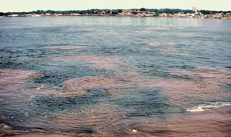
In the distance of the photograph is the city of Santarém in the western part of the state of Pará. The city is located at the confluence of the Amazon River and the Tapajós . The Tapajós River, like many rivers that originate in the Brazilian Plateau, is a river with clear water with little sediment. Off the coast of the city of Santarém, you can see the 'water meeting' where this clear water mixes with the muddy brown waters of the Amazon River. The 'water meeting' between the black waters of the Negro River and the muddy waters of the Amazon River in Manaus is famous, but the one in Santarém is also quite spectacular, as shown in this photo.
In recent years, the Cuiabá-Santarém Road from the state of Mato Grosso, upstream of the Tapajós River, to the banks of the Amazon, has been paved throughout. Santarém has a large grain terminal facility of grain major Cargill. Soybeans from the state of Mato Grosso, Brazil's largest producer, are now transported to Santarém for export using this road.
Photographed on August 10, 1981 Camera position; (Latitude and Longitude):-2 24 42.67, -54 42 46.54 (Google Map) Shooting direction:154°clockwise from north
PanoraGeo-No.737
| Previous Page | Next Page ↓ |
| Follow the Amazon River | 19 /21 | Previous Page | Next Page |

Natural canal connecting the Amazon River and the Pará River
Three nights on board after leaving Manaus in the middle Amazon and waking up in the morning, the liner bound for Belém was sailing slowly on the Tajapuru Channel (Furo do Tajapuru), which runs west of Marajó Island from north to south. Already, it is at the mouth of the Amazon.
The Tajapuru Channel is a natural canal that connects the main Amazon River with the Pará River that runs parallel to the south. This kind of waterway, which connects one river to another river or lake, is called a furo locally. To the west of Marajó Island, a few waterways, including the Tajapuru Channel, flow with a series of branches and confluences, creating the Channels Zone (Feixe de Canais) separating Marajó Island from the mainland. (See:Satellite image of the mouth region of the Amazon River)。 Ships on the Belém-Manaus route often use the Tajapuru Channel, the shortest of these waterways. The riverbank is dotted with houses, and residents come and go in canoes. The brown and turbid water in the waterways is due to the large inflow of turbid water from the Amazon River. At this point, it's only one day to Belém.
Photographed on July 14, 1981 Camera position; (Latitude and Longitude):-1 21 53.61, -50 48 8.39 (Google Map) Shooting direction:180°clockwise from north
PanoraGeo-No.398
| Previous Page | Next Page ↓ |
| Follow the Amazon River | 20 /21 | Previous Page | Next Page |

Delta-like landform in the Channels Zone of the mouth of the Amazon
This is a southerly view of the Amazonian Channels Zone with several waterways separating Marajó Island from the mainland to the west. The wide water surface in the upper left is called the Pará River, but it is actually the innermost part of the Southern Estuary, which limits the south of Marajó Island.
The following is a description of the area: "Sioli also does not consider the mouth of the Amazon to be a true delta, but rather a broad estuary; For this author, the true delta in the Amazon is one formed by the many "furos" (waterways) between Marajó Island and the mainland, flowing into Bocas Bay at the western end of the "Pará River".*1) Sioli is the name of Harald SIOLI, a renowned researcher on the nature of the Amazon, who published this view in 1966. To add to what he says: the landform of the Amazon mouth area (especially the Northern Estuary) looks like an estuarine delta at first glance, because countless islands of various sizes distributed on the water surface of trumpet shape. However, there is almost no delta in the strict sense of the word in the mouth area of the Amazon River, and only the area of this photo can be said to be a delta.
Since I have no access to Sioli's original paper, I am not sure why he made such a judgment. However, recent topographic and geological data indicate that many of the islands at the mouth of the Amazon are Pleistocene uplands or newer low-lying uplands, and are not delta islands *2) in the strict sense. Therefore, his view seems to be fundamentally correct(See:1:1,000,000 topographic map issued by the Brazilian Institute of Geography and Statistics (IBGE)).
However, if you look at the larger-scale maps of the IBGE, it becomes doubtful whether this Cannels zone that Sioli thought as a delta is a delta or not. These maps show independent elevation points in places, and the islands in the area shown in this photo are marked as 21m, 25m, 31m, 40m, etc. (See:1:250,000 IBGE map ) In other words, these islands are slightly undulating uplands (terra firme) similar to the western part of Marajó Island and the coast of the mainland, and not delta islands where sediment deposits every time they flood.
In the end, it is concluded that there is no large-scale delta in the area at the mouth of the Amazon.
*1)Soares, Lucio de Castro (1977) : in Geografia do Brasil – Região Norte, p.149, IBGE.
Original text:Por sua vez, Sioli também não considera a boca do Amazonas um verdadeiro delta, mas sim um extenso e largo estuário; para este autor, o verdadeiro delta do Amazonas está entre a Ilha do Marajó e o continente, e é formado pelo feixe de 'furos' que desembocam na Baía das Bocas, esta situada na extremidade ocidental do 'Rio Pará'.
*2)In the strict sense of the word, the delta island is a lowland, or floodplain, made up of new sediment deposited by the rivers that currently flow through it, and whose height is not much different from the surface of the river.
Photographed on August 8, 1993 Camera position; (Latitude and Longitude):-1 44 0.37, -50 33 8.99 (Google Map) Shooting direction:160°clockwise from north
PanoraGeo-No.410
| Previous Page | Next Page ↓ |
| Follow the Amazon River | 21 /21 | Previous Page | Content↓ |

Pará River(Southern Estuary)& Marajó Island
The part in the back of the Southern Estuary south of Marajó Island in the Amazon mouth area is called the Pará River, and the part closer to the open sea is called Marajó Bay. The boundary between the river and the bay is not clear, but the photo shows a view of Marajó Island from the Pará River near Marajó Bay. Both the tributaries of the upper Pará River and the large Tocantins River, which flows from the southern bank, are rivers that flow clear water with little sediment, but the turbid water of the Amazon flows in through the channels west of Marajó Island, so the water of the Pará River is brown and turbid. At this point, the river is about 15 km wide, more like a bay than a river, but freshwater.
Behind, a slight drop in the middle of the low, flat skyline of Marajó Island, indicates the mouth of a large river flowing out of the island, and is an important marker of navigation.
Photographed on August 1, 1993 Camera position; (Latitude and Longitude):-1 39 31.33 -49 3 24.13 (Google Map) Shooting direction:350°clockwise from north
PanoraGeo-No.41
| Previous Page | Content↓ | Top page |
